Brent Park (Barnet)
Brief Description
Brent Park was opened to the public in 1934. It is on the site of Brent Bridge House, demolished in 1935, whose grounds contained Decoy Wood and a small stream forming a narrow lake, with the house situated at the southern tip. The lake was created as a duck decoy and the farmland surrounding it was known as Decoy Farm. A stretch of the lake remains, crossed in the north by a rustic bridge, with a perimeter walk between thickly wooded banks, with some mature evergreen specimens surviving close to the site of the former house.
Practical Information
- Previous / Other name:
- Decoy Farm
- Site location:
- North Circular Road/Bell Lane/Brent Street, Hendon
- Postcode:
- NW4 2LT
- What 3 Words:
- skips.known.tested
- Type of site:
- Public Park
- Borough:
- Barnet
- Open to public?
- Yes
- Opening times:
- unrestricted
- Special conditions:
- no cycling/fishing
- Facilities:
- Playground
- Events:
- Public transport:
- Tube: Brent Cross (Northern). Bus 26, 82, 102, 112, 232, 260.


- Research updated:
- 01/04/2002
- Last minor changes:
- 19/07/2023
Please check with the site owner or manager for latest news. www.barnet.gov.uk
Full Site Description
Brent Park is on the site of Brent Bridge House, the grounds of which are shown on the OS map of 1875 as comprising Decoy Wood and a small stream forming a narrow serpentine lake, with the house situated at the southern tip. The lake was created as a duck decoy, possibly as long as 1,000 years ago by Abbots of Westminster, and the farmland surrounding it was known as Decoy Farm. The North Circular Road now abuts the site on its eastern side, and C20th residential development has encroached on the perimeters. A stretch of the lake remains traversed at its northern tip by a bridge of rustic stonework, with a perimeter walk between thickly wooded banks, with some mature evergreen specimens surviving close to the site of the former house, which was demolished in 1935.
Brent Park opened to the public in 1934 and is entered in the south via a small entrance tucked away off Brent Street and leads to a wooded path along the stream; a small circular dilapidated pavilion with a tiled roof is hidden among the trees near this entrance. Old iron railings border the park on Brent Street over the stream, which then flows into a culvert the other side of the road, south of Brent Park. The wooded path runs on the west side of the stream at first, alongside new housing and lawns, to a small timber bridge. The path then continues on the east side, dominated by the sound of the North Circular Road. This area feels distinctly abandoned, a scrubby landscape with much rosebay willowherb, blackberries, nettles etc. but also some very large mature trees. The park proper begins just south of the small lake, which has a tarmac path around it with some seating, new notices and low wooden railings edging the path, plus information boards about the wildfowl. There are small areas of mown grass with benches/bins to the north, and throughout some interesting trees have been planted, including swamp cypress.
Sources consulted:
Jan Hewlett, Ian Yarham, David Curson, 'Nature Conservation in Barnet' (London Ecology Unit, 1997).
Further Information (Planning and Conservation)
- Grid ref:
- TQ239887 (524018,188816)
- Size in hectares:
- 2.24
- Site ownership:
- LB Barnet
- Site management:
- Leisure and Youth Services, Green Spaces Division
- Date(s):
- C19th; 1934
- Designer(s):
- Listed structures:
- None
- On National Heritage List for England (NHLE), Parks & Gardens:
No- Registered common or village green on Commons Registration Act 1965:
No- Protected under London Squares Preservation Act 1931:
No
Local Authority Data
The information below is taken from the relevant Local Authority's planning legislation, which was correct at the time of research but may have been amended in the interim. Please check with the Local Authority for latest planning information.
- On Local List:
- No
- In Conservation Area:
- No
- Tree Preservation Order:
- Not known
- Nature Conservation Area:
- Yes - Boro Importance II
- Green Belt:
- No
- Metropolitan Open Land:
- Yes
- Special Policy Area:
- Yes - Area of Special Archaeological Significance
- Other LA designation:
- Local Park; Capital Ring through park
Photos
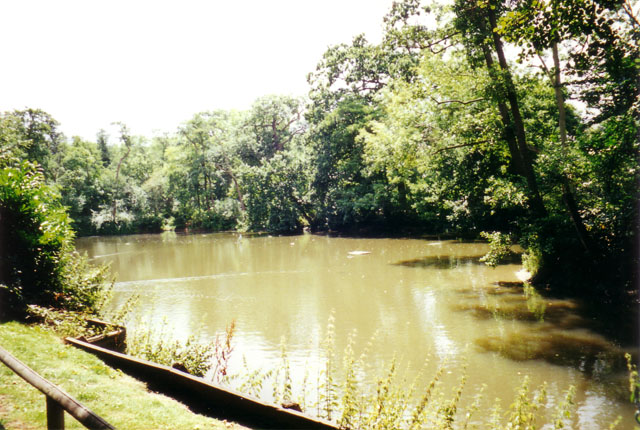
Brent Park, Lake, July 2000. Photo S Williams

2000 
2000 
2000 
2000 
Click a photo to enlarge.
Please note the Inventory and its content are provided for your general information only and are subject to change. It is your responsibility to check the accuracy.