St Bartholomew's Gardens (Tower Hamlets)
Brief Description
This is the former burial ground of St Bartholomew's Church, which following its closure was re-ordered as a public garden by the MPGA. It opened to the public in 1885 and apart from one memorial there is no evidence of its former use. The garden was extended in the south in the 1970s. The church, built in 1843-4, was damaged in WWII and later restored; it was converted into flats in the 1990s.
Practical Information
- Site location:
- Coventry Road/Buckhurst Street
- Postcode:
- E1
- What 3 Words:
- visual.organs.drag
- Type of site:
- Public Gardens
- Borough:
- Tower Hamlets
- Open to public?
- Yes
- Opening times:
- unrestricted
- Special conditions:
- Facilities:
- Events:
- Public transport:
- Tube: Whitechapel (District, Hammersmith & City, Metropolitan), Bethnal Green (Central). London Overground: Whitechapel. Bus: 253.


- Research updated:
- 26/07/2021
- Last minor changes:
- 19/07/2023
Please check with the site owner or manager for latest news. www.towerhamlets.gov.uk
Full Site Description
St Bartholomew's Church was built in 1843-4 and designed by William Railton. After the churchyard closed to burials it was re-ordered as a public garden by the MPGA and was opened to the public in 1885 by Princess Louise. In March 1884 Fanny Wilkinson, who had just been elected honorary landscape gardener to the MPGA, had obtained a contractor's estimate to lay out St Bartholomew's burial ground to her designs, making the following observations on the submitted costs: 'if with gravel paths and wood edging for £160; if with asphalt paths, for £245, and an extra iron guard railing would cost £57 if required'. Gravel paths were provided initially, deemed to be more attractive but also cheaper, although two years later the paths needed to be asphalted due to the large numbers of people passing through the garden, which was estimated to be 1,500 a day.
St Bartholomew's Gardens were maintained by the London County Council, who in the inter-war years built the large Collingwood Estate that now surrounds the small park. The first block of housing opened in 1923, and the estate was substantially complete by 1930 although it continued to be enlarged into the 1970s. St Bartholomew's Gardens were extended to the south in c.1973 where some of the ground is undulating. There is an obelisk to Tanner Lucas, c.1840, but otherwise no gravestones remain as evidence of its former history. The garden is largely laid to grass with perimeter planting and contains some holly, notable planes, ash and sycamore, and a few rose beds. A children’s playground is in the far corner of the site.
St Bartholomew's Church was damaged by bombing in WWII and was later restored and converted for residential use in the 1990s, re-named 'Steeple Court'. A public footpath, St Bartholomew's Path, flanked by iron railings, divides the church and the public gardens, which retain a proportion of the original C19th railings along this path, as well as partially on Coventry Road and Buckhurst Street, with iron coping on a brick parapet.
Sources consulted:
Bancroft Library, Clippings. Lieut. Col J J Sexby, The Municipal Parks, Gardens and Open Space of London (their History and Associations, Elliott Stock (London) 1895 (1905 edition); Mrs Basil Holmes, The London Burial Grounds, London, 1896; Bridget Cherry, Charles O'Brien, Nikolaus Pevsner, 'The Buildings of England, London 5: East', Yale University Press, 2005; Elizabeth Crawford, 'Enterprising Women: The Garretts and their Circle' (Francis Boutle Publishers, 2nd ed. 2009)
Further Information (Planning and Conservation)
- Grid ref:
- TQ349822 (534950,182250)
- Size in hectares:
- 0.4615
- Site ownership:
- LB Tower Hamlets
- Site management:
- Leisure Services, Parks and Open Spaces
- Date(s):
- 1844; 1885; 1970s
- Designer(s):
- 1884/5: MPGA (Fanny Wilkinson)
- Listed structures:
- None
- On National Heritage List for England (NHLE), Parks & Gardens:
No- Registered common or village green on Commons Registration Act 1965:
No- Protected under London Squares Preservation Act 1931:
No
Local Authority Data
The information below is taken from the relevant Local Authority's planning legislation, which was correct at the time of research but may have been amended in the interim. Please check with the Local Authority for latest planning information.
- On Local List:
- No
- In Conservation Area:
- No
- Tree Preservation Order:
- No
- Nature Conservation Area:
- No
- Green Belt:
- No
- Metropolitan Open Land:
- No
- Special Policy Area:
- No
- Other LA designation:
- None
Photos
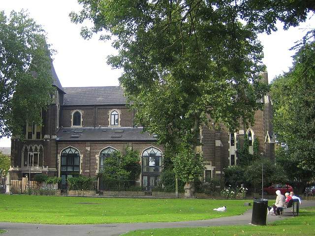
St Bartholomew's Church from the public gardens, September 2008. Photo: S Williams

2008 
2008 
2008 
2008 Click a photo to enlarge.
Please note the Inventory and its content are provided for your general information only and are subject to change. It is your responsibility to check the accuracy.