Ravenscroft Gardens (Barnet)
Brief Description
This was once within Barnet Common, which had been partly enclosed in 1729 and the remainder in 1815. In the 1880s when housing and a new road were being built here, a small area of remaining open land with a pond was converted into this public park. Initially called Barnet Recreation Ground, it was later named after James Ravenscroft, a great benefactor of Barnet. It was laid out with serpentine walks, shrubs and bedding. There used to be two ornamental ponds that were drained in 1992, their location marked as sunken areas.
Practical Information
- Previous / Other name:
- Barnet Common; Barnet Recreation Ground
- Site location:
- Wood Street/Ravenscroft Park, Chipping Barnet
- Postcode:
- EN5 4ND
- What 3 Words:
- mess.shady.planet
- Type of site:
- Public Park
- Borough:
- Barnet
- Open to public?
- Yes
- Opening times:
- unrestricted
- Special conditions:
- No horse riding
- Facilities:
- Events:
- Public transport:
- Tube: High Barnet (Northern) then bus. Bus: 107, 263, 307, 384


- Research updated:
- 01/04/2002
- Last minor changes:
- 29/03/2026
Please check with the site owner or manager for latest news. www.barnet.gov.uk
Full Site Description
Barnet Common at one time went from Barnet Hill to Barnet Gate and was used for pasture for horses when horse fairs were taking place in the area. Part of the common was enclosed in 1729 and the rest in 1815 and the small area of remaining open land with a pond later became Barnet Recreation Ground in the 1880s, later renamed Ravenscroft Park. James Ravenscroft after whom the park is named was a great benefactor of Barnet, 'a man of untarnished integrity, of a happy disposition, exceedingly well known for the greatness of his mind' according to the tomb in St John the Baptist churchyard (q.v.). In 1880s when a new road and housing was developed by Thomas Smith, he paid for the conversion of an area formerly Barnet Common into a public park.
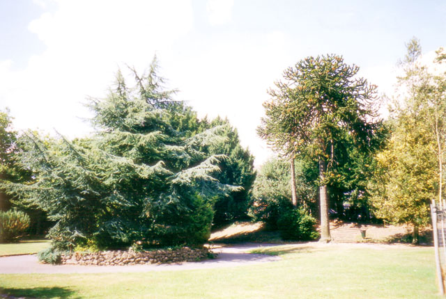
The park is surrounded by C19th iron railings. An early C20th photograph shows a railed enclosure adjacent to brick terraces, laid out with serpentine walks, shrubs and bedding. There used to be two ornamental ponds, which were drained in 1992, their remains marked as sunken areas. Just outside the park is a boundary stone with the following inscription: 'This stone stands on the pre-historic landmark Grimsdyke which forms part of the boundary of Chipping Barnet. This stone was originally a boundary stone of the Whetstone and Highgate Turnpike Trust which built Barnet Hill about 1823'. The park has a fine collection of mature trees of good variety including horse chestnuts and evergreen trees such as fir and 2 monkey puzzles.
Sources consulted:
P Taylor and J Cordern, 'Barnet, Edgware, Hadley and Totteridge', 1994; Arthur Mee 'The King's England: London North of the Thames except the City and Westminster' (Hodder & Stoughton Ltd, 1972); Andrew Duncan, 'Walking Village London', (New Holland, 1997); Jan Hewlett, Ian Yarham, David Curson, 'Nature Conservation in Barnet', (London Ecology Unit, 1997); Barnet Online Pocket History
Further Information (Planning and Conservation)
- Grid ref:
- TQ239964 (523989,196454)
- Size in hectares:
- 1.26
- Site ownership:
- LB Barnet
- Site management:
- Leisure and Youth Services, Green Spaces Division
- Date(s):
- 1883-5
- Designer(s):
- Thomas Smith?
- Listed structures:
- LBII: Boundary stone adjacent to park
- On National Heritage List for England (NHLE), Parks & Gardens:
No- Registered common or village green on Commons Registration Act 1965:
No- Protected under London Squares Preservation Act 1931:
No
Local Authority Data
The information below is taken from the relevant Local Authority's planning legislation, which was correct at the time of research but may have been amended in the interim. Please check with the Local Authority for latest planning information.
- On Local List:
- No
- In Conservation Area:
- Yes
- Conservation Area name:
- Wood Street
- Tree Preservation Order:
- Not known
- Nature Conservation Area:
- No
- Green Belt:
- No
- Metropolitan Open Land:
- No
- Special Policy Area:
- Yes - Area of Special Archaeological Significance
- Other LA designation:
- Small Local Park. Article 4 Direction
Photos
Ravenscroft Gardens, August 2000. Photo: S Williams

2000 
2000 
2000 
1880 
Click a photo to enlarge.
Please note the Inventory and its content are provided for your general information only and are subject to change. It is your responsibility to check the accuracy.