Mortlake Green (Richmond)
Brief Description
Mortlake Green was the old village green for the hamlet of Mortlake. The Manor was owned by the Archbishops of Canterbury, whose riverside palace had its gatehouse facing the Green. After 1536 the manor was taken by Henry VIII and the manor house was eventually demolished in the C18th, its site later developed as a brewery. Mortlake became a popular residential village in the C16th although the smell from the brewery later led to its decline. Once known as Kings Arms Field, in 1860 Mortlake Green was donated to the residents of Mortlake by Earl Spencer, Lord of the Manor, for public open space.
Practical Information
- Previous / Other name:
- Kings Arms Field
- Site location:
- Sheen Lane/Lower Richmond Road, Mortlake
- Postcode:
- SW14 8HY
- What 3 Words:
- pans.loudly.feels
- Type of site:
- Public Open Land
- Borough:
- Richmond
- Open to public?
- Yes
- Opening times:
- Mon-Sat 7.30am-dusk; Sun 9am-dusk.
- Special conditions:
- Facilities:
- Play areas
- Events:
- Public transport:
- Rail: Mortlake. Bus: 419


- Research updated:
- 29/01/2022
- Last minor changes:
- 19/07/2023
Please check with the site owner or manager for latest news. www.richmond.gov.uk/parks_and_open_spaces
Full Site Description
The Mortlake Tapestry Works were founded in 1619 and became famous but after the Civil War they declined and the workshop closed in 1703. Other industries developed along the riverside including potteries and breweries. The site of the manor house was developed as a brewery and later became the Stag Brewery, which remained in operation until 2015. However, this increasing industrialisation and the smell from malting and brewery led to the decline of Mortlake as a fashionable riverside retreat.
Formerly known as Kings Arms Field, the land that is now Mortlake Green was given to the residents of Mortlake for public recreation by Earl Spencer in 1860. Postcards of the Edwardian era show that it was landscaped with low terraces, an elaborate path system, shrub and flower beds, grass and trees. Today it is a rectangular space bounded on one side by the railway and by busy roads on two other sides. It features a tarmac playground, grass, shrubs and mature trees, with three shallow stepped terraces from the railway with low stone walls between them. A small paved area with brick planters and seating on Sheen Lane probably dates from the late C20th. A seat in the upper terrace commemorates Queen Elizabeth II's Silver Jubilee. A mound surrounded by a low rail was created and planted in c.1985 by Mortlake Brewery, which lies opposite the green, to commemorate 500 years of brewing in Mortlake.
Stag Brewery ceased brewing operations in late 2015 and the site was sold. A number of historic assets remain such as the former bottling building, the Maltings building and the former hotel building, along with historic brick boundary structures. Richmond Council is keen for development here that creates a new centre for Mortlake, with the opportunity to create a new publicly accessible link to the river from Mortlake Green and provide additional publicly green space.
Sources consulted:
Ben Weinreb & Christopher Hibbert, 'The London Encyclopaedia' (Macmillan, revised ed. 1993); Thames Landscape Strategy; Richmond Council Local Plan consultation document
Further Information (Planning and Conservation)
- Grid ref:
- TQ204759 (520438,175885)
- Size in hectares:
- 1.46
- Site ownership:
- LB Richmond
- Site management:
- Environment Planning & Review, Parks and Open Spaces
- Date(s):
- 1860
- Designer(s):
- Listed structures:
- None
- On National Heritage List for England (NHLE), Parks & Gardens:
No- Registered common or village green on Commons Registration Act 1965:
Yes: Green (TVG2)- Protected under London Squares Preservation Act 1931:
No
Local Authority Data
The information below is taken from the relevant Local Authority's planning legislation, which was correct at the time of research but may have been amended in the interim. Please check with the Local Authority for latest planning information.
- On Local List:
- No
- In Conservation Area:
- Yes
- Conservation Area name:
- Mortlake
- Tree Preservation Order:
- No
- Nature Conservation Area:
- No
- Green Belt:
- No
- Metropolitan Open Land:
- No
- Special Policy Area:
- No
- Other LA designation:
- Open Land of Townscape Importance; proposed area of environmental improvements
Photos
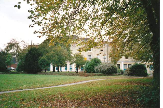
Mortlake Green with terracing to rear, October 2001. Photo S Williams

2001 
2001 
2001 


Click a photo to enlarge.
Please note the Inventory and its content are provided for your general information only and are subject to change. It is your responsibility to check the accuracy.