St Matthew's Church Garden (Tower Hamlets)
Brief Description
The parish of Bethnal Green was created in 1742, and the new church of St Matthew was consecrated in 1746, although an earlier church had been proposed under the Fifty New Churches Commissioners. The population had grown particularly following the arrival of Huguenots, who established their textile industry here. The Watch House in the churchyard was built in 1754 as a measure to prevent body snatching. The churchyard closed for burials in the mid 1850s and in 1896 was turned into a public garden when the majority of tombs were removed. Two railed tombs remain, including that of former churchwarden Joseph Merceron. It is mostly grassed over, with large plane trees by an oval path to the north of the church. There are remains of the C19th railings on the boundary with St Matthew’s Row. A rose garden is to the south of the church and an area to the east has formal beds, palms and other ornamental planting.
Practical Information
- Site location:
- St Matthew's Row/Wood Close/Hereford Street
- Postcode:
- E2
- What 3 Words:
- jokes.half.mock
- Type of site:
- Public Gardens
- Borough:
- Tower Hamlets
- Open to public?
- Yes
- Opening times:
- unrestricted
- Special conditions:
- Facilities:
- Events:
- Public transport:
- Tube: Bethnal Green (Central) then bus. London Overground: Shoreditch High Street. Rail: Bethnal Green then bus. Bus: 8, D3


- Research updated:
- 01/07/2013
- Last minor changes:
- 14/07/2022
Please check with the site owner or manager for latest news.
Full Site Description
Proposals for a separate parish of Bethnal Green were being discussed in the 1690s, at which time the village of Bethnal Green was within the large parish of Stepney. The original site proposed for a new church of St Matthew was on Bethnal Green common lands, now the location of Bethnal Green Gardens (q.v.), but this was refused by the Trustees of the Poor Land's Charity who held the land. Following the Fifty New Churches Act of 1711, the Fifty New Churches Commissioners eventually purchased a piece of land to the west, which was part of Hare Fields; Hare Street was the old name of Cheshire Street. Although at a distance from the village centre, the population of this area had developed particularly following the arrival of Huguenots fleeing persecution, who established their silk and textile industry here. The new parish was created by Act of Parliament in 1742. The church was designed by George Dance the Elder, although an earlier scheme for a much larger building had been drawn up by Nicholas Hawksmoor, a 'Basilica after the Primitive Christians'. Dance's church was consecrated in 1746.
The churchyard witnessed more than burials at times, an adjacent piece of land was used for dog and bullock baiting in the C18th and this led on at least one occasion to an interruption of the Sunday service by the arrival of a fleeing animal seeking refuge following a chase through the churchyard. It was also subject to body snatching and to counteract this the Watch House was built in 1754. The watchman was issued with 'blunderbuss and rattle' to apprehend miscreants. The Watch House was later expanded to house the parish fire engine. Like many overcrowded churchyards in London, its closure came as a result of the first Burial Act of 1852 and its subsequent amendments during the 1850s. The Metropolitan Open Spaces Acts of 1877 and 1881 and the Disused Burial Grounds Act of 1884, later extended under the Metropolitan Open Spaces Act of 1887, enabled 'open spaces and burial grounds in the Metropolis for the use of the inhabitants thereof for exercise and recreation'. In 1896 the churchyard was converted into a public garden, the work undertaken by Fanny Wilkinson, landscape gardener of the MPGA. The majority of tombs were removed and listed in the Central Registry Office, although two railed tombs remain. One is that of Joseph Merceron (1764-1839), former churchwarden and licensing magistrate who spent a period in prison for running a protection racket and appropriating nearly £1,000 of church funds, but he returned to his former offices, was elected Senior Curate and lived to an old age and a local street is named after him. The second tomb, which has been renovated and rededicated in 2013, is the family tomb of Peter Renvoize (1757-1842). Renvoize was also implicated with Merceron in stealing the church poor funds in 1819. However, he was also a benefactor of Parmiter's School, founded by silk merchant Thomas Parmiter in Bethnal Green, and which moved to Watford in the 1980s.
St Matthew's has some notoriety as the local church of the Kray Twins who lived nearby in Vallance Road and it was used for Kray funeral services including that of Ronnie Kray on 23 March 1995. A huge cortege accompanied by 27 Daimlers led by a hearse with 6 plumed black horses processed from St Matthew's to Chingford Mount Cemetery (q.v.).
The churchyard garden is now maintained by LB Tower Hamlets, but is owned by the church, who also have responsibility for maintenance of footpaths. It is mostly grassed over, with fine large plane trees around an oval path to the north of the church. There are remains of the C19th railings on the boundary with St Matthew’s Row, the rest of the railings are C20th. A rose garden is laid out to the south of the church and there is an area to the east with formal beds, palms and other ornamental planting.
Sources consulted:
Fr John Oldland, 'A History of the Parish Church of Saint Matthew Bethnal Green', 1989; Iain Sinclair, Lights Out for the Territory; East London Advertiser, 30 March 1995; Sally Williams 'Bringing out the Dead, in The London Gardener, volume V for 1999-2000; LB Tower Hamlets, 'Brick Lane and Fournier Street Conservation Area Character Appraisal and Management Guidelines', 2009; Elizabeth Crawford, 'Enterprising Women: The Garretts and their Circle' (Francis Boutle Publishers, 2nd ed. 2009); The Gentle Authur, Spitalfields Life, 'The Return of Parmiter's School' (posted 29 June 2013)
Further Information (Planning and Conservation)
- Grid ref:
- TQ341824 (534150,182450)
- Size in hectares:
- 0.8328
- Site ownership:
- Church - garden leased to LB Tower Hamlets
- Site management:
- LB Tower Hamlets Leisure Services, Parks & Open Spaces
- Date(s):
- 1740s, 1896/97
- Designer(s):
- 1896/97: MPGA (Fanny Wilkinson)
- Listed structures:
- LBII*: St Matthew's Church. LBII: Watch House; railings to churchyard; No. 2 St Matthew's Row
- On National Heritage List for England (NHLE), Parks & Gardens:
No- Registered common or village green on Commons Registration Act 1965:
No- Protected under London Squares Preservation Act 1931:
No
Local Authority Data
The information below is taken from the relevant Local Authority's planning legislation, which was correct at the time of research but may have been amended in the interim. Please check with the Local Authority for latest planning information.
- On Local List:
- No
- In Conservation Area:
- Yes
- Conservation Area name:
- Brick Lane and Fournier Street
- Tree Preservation Order:
- No
- Nature Conservation Area:
- No
- Green Belt:
- No
- Metropolitan Open Land:
- No
- Special Policy Area:
- No
- Other LA designation:
- None
Photos
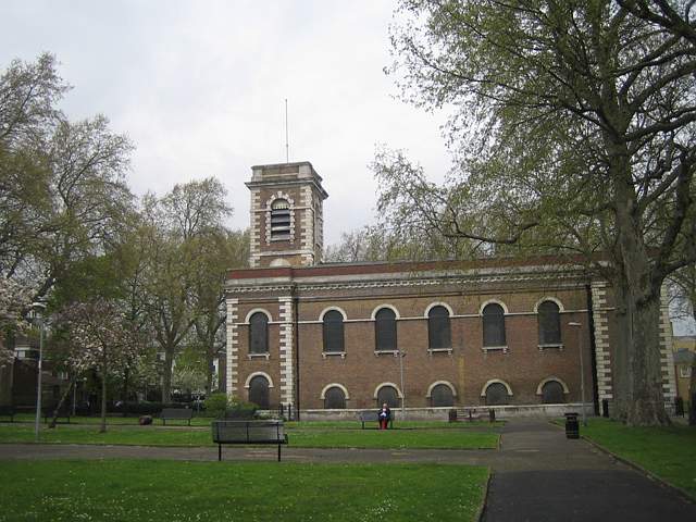
St Matthew's Church, April 2010. Photo: S Williams

2010 
2010 
2010 
2010 
1818 Click a photo to enlarge.
Please note the Inventory and its content are provided for your general information only and are subject to change. It is your responsibility to check the accuracy.