Whittington Garden (City of London)
Brief Description
The Whittington Garden is named after Lord Mayor Richard Whittington, who rebuilt the church of St Michael Paternoster Royal at his own expense in 1409, also founding a college and almshouses. Destroyed in the Great Fire of London in 1666, the church was rebuilt by Wren by 1694. The site of the public garden was on the riverbank in Roman times and later had buildings connected with the fur trade. These were demolished after bomb damage in WWIII and the Corporation of London acquired the site in 1955. The garden was laid out in 1960 with a largely paved area in the west and grass, flower beds and trees in the east. A small fountain was erected in the west section in the late 1960s. The east section is now surrounded by hedge, and remains largely grass, shaded by trees.
Practical Information
- Site location:
- College Street/Upper Thames Street
- Postcode:
- EC4R 2RL
- What 3 Words:
- fumes.scans.weeks
- Type of site:
- Public Gardens
- Borough:
- City of London
- Open to public?
- Yes
- Opening times:
- unrestricted. Church: Mon-Fri 9am-5pm
- Special conditions:
- Facilities:
- Events:
- Public transport:
- Tube: Cannon Street (District, Circle)


- Research updated:
- 01/06/2010
- Last minor changes:
- 29/03/2026
Please check with the site owner or manager for latest news. www.cityoflondon.gov.uk/openspaces
Full Site Description
The Whittington Garden is named after the Lord Mayor Richard Whittington (d.1423) who was buried in St Michael Paternoster Royal Church, which he had rebuilt at his own expense in 1409. An earlier church of 1219 is referred to in C13th documents. He also founded a college and almshouses on which he bestowed the rights and profits of the church, having been granted a piece of land for the purpose by City of London. This church was destroyed in the Great Fire of London and rebuilt by Wren by 1694, its steeple erected in 1713. The Wren church is set back from the main road behind Whittington Garden, which is laid out in two parts, separated by hedge. One part is grassed, railed and locked and the other is largely paved, with seats, small fountain and shrubs. In Roman times the site of the gardens was on the riverbank and later had buildings connected to the fur trade, but these were demolished after bomb damage in World War II.
The Corporation of London acquired the site in 1955, ownership of part of it being exchanged in 1956 for the graveyard of St Martin Vintry, a parish that was united with that of St Michael Paternoster Royal after the Great Fire of 1666. St Martin Vintry dated from the C12th with a churchyard in existence by 1211, lost due to the widening of Upper Thames Street in the 1960s. The parish of St Michael Queenhithe was amalgamated in 1875 and that of All Hallows the Great in 1894. The garden was laid out in 1960, the original layout having an open paved area to the west, with low brick walls to the north, a few trees and flowerbeds, and to the east a railed lawn with flower beds and a single tree. A small fountain was erected in the west area in the late 1960s; the east section is now surrounded by hedge and flower beds have gone. Since the 1960s some planting has been added alongside the church.
Sources consulted:
B. Cherry and N. Pevsner, 'The Buildings of England, London Vol. l: The Cities of London and Westminster', London, 1985; F E Cleary, 'The Flowering City', The City Press, 1969; George Godwin & John Britton 'The Churches of London: A history and description of the Ecclesiastical Edifices of the Metropolis, Volume II', London, 1839; London Diocesan Advisory Committee for the Care of Churches data
Further Information (Planning and Conservation)
- Grid ref:
- TQ324808 (532476,180835)
- Size in hectares:
- 0.0208
- Site ownership:
- City of London Corporation (area adjacent to church: Diocese of London)
- Site management:
- Open Spaces Dept.
- Date(s):
- C13, 1686-94; 1960
- Designer(s):
- Listed structures:
- LBI: St Michael Paternoster Royal Church
- On National Heritage List for England (NHLE), Parks & Gardens:
No- Registered common or village green on Commons Registration Act 1965:
No- Protected under London Squares Preservation Act 1931:
No
Local Authority Data
The information below is taken from the relevant Local Authority's planning legislation, which was correct at the time of research but may have been amended in the interim. Please check with the Local Authority for latest planning information.
- On Local List:
- No
- In Conservation Area:
- Yes
- Conservation Area name:
- Queen Street
- Tree Preservation Order:
- No
- Nature Conservation Area:
- No
- Green Belt:
- No
- Metropolitan Open Land:
- No
- Special Policy Area:
- Yes - St Paul's Heights Policy Area
- Other LA designation:
- Strategic Viewing Corridor
Photos
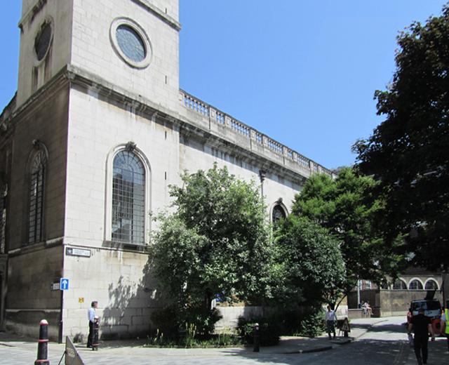
St Michael Paternoster Royal, June 2010. Photo: S Williams

2010 
2010 
2010 
2002 
1838 Click a photo to enlarge.
Please note the Inventory and its content are provided for your general information only and are subject to change. It is your responsibility to check the accuracy.