Rectory Gardens (Tower Hamlets)
Brief Description
Rectory Gardens is on the site of the former garden of St Anne's Rectory, an early C18th house that was destroyed in WWII. Now a public garden owned by Tower Hamlets Council, the roughly triangular site is bordered by the Limehouse Cut, London’s oldest canal built in 1766-9, with Commercial Road to the north and Docklands Light Railway viaduct, originally built for the London and Blackwall Railway, along its former southern boundary.
Practical Information
- Previous / Other name:
- St Anne's Rectory Gardens
- Site location:
- Commercial Road, Limehouse
- Postcode:
- E14 7HW
- What 3 Words:
- equal.rated.spins
- Type of site:
- Public Gardens
- Borough:
- Tower Hamlets
- Open to public?
- Yes
- Opening times:
- unrestricted
- Special conditions:
- Facilities:
- Events:
- Public transport:
- DLR: Limehouse.


- Research updated:
- 26/07/2021
- Last minor changes:
- 14/07/2022
Please check with the site owner or manager for latest news. www.towerhamlets.gov.uk
Full Site Description
The C18th Rectory of St Anne's Limehouse (q.v.) that gave its name to the public garden failed to survive the Blitz and a residential development now forms the garden’s western front. The garden consists of a central grass area that ramps down to meet the canal edge; mature London plane and lime trees are on the boundaries and a small grove of younger trees now occupies the Rectory’s former footprint. When the Rectory was built in 1730, a house of 17 bedrooms, Limehouse was largely rural and the house probably stood in open fields with a direct and uninterrupted relationship to St Anne’s Church. It is said that the Rector was collected each Sunday and driven to church by horse and trap. Daniel Lysons, writing in ‘The Environs of London’ (1811), described the parish of Limehouse, which contained ‘about 90 acres of land not covered by buildings: of these about 6 are market-gardens; the remainder is chiefly occupied by cowkeepers, whose stock of cattle amounts to about 100.’ In enumerating the endowment of the rectory, he also made mention of ‘the parsonage-house and garden’.
The relationship between the Rectory and St Anne's Church remained unbroken until 1766, when the construction of the Limehouse Cut was authorised by the River Lee Act. Cutting through the largely open land, it formed a short-cut between the River Thames and River Lee Navigation avoiding the curves of the lower reaches of the River Lee or Lea at Bow Creek, and the need to wait for the tide to make the long detour round the Isle of Dogs. However, like many of London’s waterways prior to the building of the Victorian sewers, The Cut became unpleasantly insanitary by the 1860s. By the mid-C19th the Rectory, now bordered on three sides, had lost its once spacious surroundings. Stanford’s 1862 Map of London shows the house with an oval garden to the west and fields to the east and south abutting the canal and railway line, with Commercial Road to the north. The First Edition OS Map of 1869 shows a definitive garden curtilage incorporating garden design to the east to complement the oval flower bed to the drive entrance. The fields to the south, between the Rectory and railway, are now replaced with buildings. The garden boundaries remain almost identical today, with only the Rectory now missing.
The LCC War Damage Map of Poplar indicates that the Rectory sustained blast damage during the Blitz, presumably leading to the building’s demolition soon afterwards. The Rectory later relocated to No.5 Newell Street closer to the church, which was formerly the site of No.12 Church Row, a house where Charles Dickens’ godfather once lived, where he was visited by the famous novelist when a boy. Prior to the demise of the Rectory its garden regularly served as the venue for the annual garden fête for the church.
Sources consulted:
Daniel Lysons, The Environs of London Volume II Part II, County of Middlesex Hornsey-Wilsdon (London, 1811), pp.537-9; Jared Lockhart, 'The Rectory Garden of St Anne's Limehouse', in The London Gardener vol. 15, 2009/10; Bridget Cherry, Charles O'Brien, Nikolaus Pevsner, 'The Buildings of England, London 5: East', Yale University Press, 2005.
Further Information (Planning and Conservation)
- Grid ref:
- TQ366810 (536612,181044)
- Size in hectares:
- Site ownership:
- LB Tower Hamlets
- Site management:
- Leisure Services, Parks and Open Spaces
- Date(s):
- 1730
- Designer(s):
- Listed structures:
- LBII: Boundary Wall to Commercial Road
- On National Heritage List for England (NHLE), Parks & Gardens:
No- Registered common or village green on Commons Registration Act 1965:
No- Protected under London Squares Preservation Act 1931:
No
Local Authority Data
The information below is taken from the relevant Local Authority's planning legislation, which was correct at the time of research but may have been amended in the interim. Please check with the Local Authority for latest planning information.
- On Local List:
- No
- In Conservation Area:
- Yes
- Conservation Area name:
- St Anne's Churchyard
- Tree Preservation Order:
- Yes
- Nature Conservation Area:
- No
- Green Belt:
- No
- Metropolitan Open Land:
- No
- Special Policy Area:
- Other LA designation:
- None
Photos
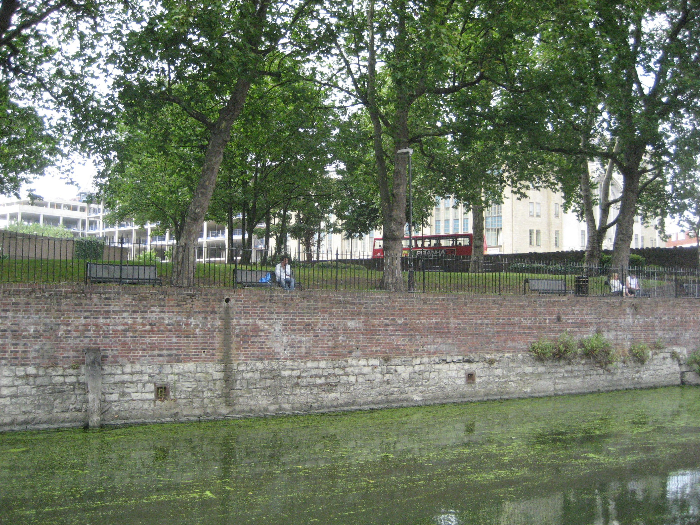
Rectory Gardens and Limehouse Cut, August 2010. Photo: Jared Lockhart

2010 ")
1816 Click a photo to enlarge.
Please note the Inventory and its content are provided for your general information only and are subject to change. It is your responsibility to check the accuracy.